Darlak: Difference between revisions
Yeshedorje (talk | contribs) |
Yeshedorje (talk | contribs) m (→Internal Links) |
||
| Line 54: | Line 54: | ||
*[[Machen]] | *[[Machen]] | ||
*[[Matö]] | *[[Matö]] | ||
*Pema | *[[Pema Dzong]] | ||
=Notes= | =Notes= | ||
Latest revision as of 11:57, 13 July 2022

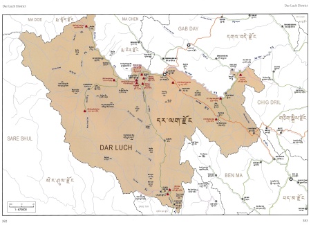
Darlak (Tib. དར་ལག་, Wyl. dar lag), aka Darlak County (Tib. དར་ལག་རྫོང, Wyl. dar lag rdzong, Chin. Dárì Xiàn 达日县), is a county division of Golok.
Located south-eastern Qinghai province, China, it is bordering Sichuan to the southeast and Gansu to the northeast. It is under the administration of Golok Tibetan Autonomous Prefecture. The county seat is in the town of Khangsar (Tib. ཁང་གསར་, Wyl. khang gsar; Ch. Chugqênsumdo, 久治).[1]
Geography
Position
Darlak borders Chikdril to east, Pema (Tib. པདྨ་, Wyl. pad+ma) County to southeast, Serta County of the Sichuan Province to south, Dzachukha aka Sershul (Tib. སེར་, Wyl. ser shul) to southwest, Matö County to the northwest, and Machen (Tib. རྨ་ཆེན་, Wyl. rma chen) and Gadé (Tib. དགའ་བདེ་, Wyl. dga’ bde) County to the north across the Ma Chu (Yellow River). Darlak is second county to Matö at the source of the Ma Chu (Yellow River). It is also a distribution center for important commodities and Chinese and Tibetan medicinal ingredients in the Golok Prefecture, and an important transportation hub at the junction of Qinghai and Sichuan. [2], [3]
Rivers

The county’s main river, the Darlak Chu (Tib. དར་ལག་ཆུ་, Wyl. dar lag chu), shares its name with the county itself and is located in its centre, flowing northwards into the Ma Chu (Tib. རྨ་ཆུ་, Wyl. rma chu), as does the Ko Chu (Tib. ཁོ་ཆུ་, Wyl. kho chu) in the west and the Gyü Chu (Tib. རྒྱུད་ཆུ་, Wyl. rgyud chu) in the east. The Ma Chu thus marks the northern border of Darlak. [4]
Climate
With an elevation of around 3,970 metres (13,020 ft), Darlak County has an alpine climate, bordering on a subalpine climate, with long, very cold winters, and short, rainy, cool summers. Average low temperatures are below freezing from mid-September to late May; however, due to the wide diurnal temperature variation, average highs are only below freezing from mid/late November thru early March. With monthly percent possible sunshine ranging from 47% in June to 70% in November, the county seat receives 2,467 hours of bright sunshine annually. The monthly 24-hour average temperature ranges from −12.0 °C in January to 9.8 °C in July, while the annual mean is −0.53 °C. Over 70% of the annual precipitation of 558 mm is delivered from June to September.[5]
Cities
The main cities of Darlak county are the following: [6]
- Dzugtrün (Tib. འཛུགས་སྐྲུན་, Wyl. ‘dzugs skrun, Ch. Dzugtrün 建设乡) has about 3,430 residents. [7]
- Gyüme (Tib. རྒྱུད་སྨད་, Wyl. rgyud smad, Ch. Gyümai 吉迈). The seat of Darlak County is situated in the Town of Gyüme. Gyüme has an altitude of 3,970 m. The average annual temperature is −1.2 °C, and the average annual precipitation is 531.5 mm. The town has a population of about 8,700. [8]
- Martring (Tib. སྨར་འཕྲིང་, Wyl. smar ‘phring, Ch. Marzhing 满掌) has about 2,660 residents and an elevation of 4,174 metres. [9]
- Mopa (Tib. མོ་པ་, Wyl. mo pa, Ch. Moba 莫坝) has about 2,150 residents and an elevation of 4,246 metres. [10]
- Öser (Tib. འོད་ཟེར་, Wyl. ‘od zer, Ch. Özer 窝塞乡) has about 1,710 residents. [11]
- Pönkor Töma (Tib. དཔོན་སྐོར་སྟོད་མ་, Wyl. dpon skor stod ma, Ch. Pönkor Töma 上红科) has about 3,260 residents and an elevation of 4,254 metres. [12]
- Sangruma (Tib. གསང་རུ་མ་, Wyl. gsang ru ma, Ch. Sangruma 康龙达) has about 2,380 residents and an elevation of 4,256 metres. [13]
- Tagtog (Tib. སྟག་ཐོག་, Wyl. stag thog, Ch. Tehetu 查木觉达) In 2010, the township had a total population of 1,600. [14]
- Tenang (Tib. སྟེ་ནང་, Wyl. ste nang, Ch. Dêrnang 德昂) has about 2,720 residents and an elevation of 4,420 metres. [15]
Dharma
Dharma Lineages
The main tradition lineages practised in Darlak are related to
Main Dharma Places
The main Dharma places are:[16] [17]
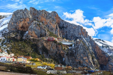
- Traling (Tib. ཁྲ་གླིང་དགོན་ཐུབ་བསྟན་བཤད་སྒྲུབ་ནོར་བུའི་དགའ་ཚལ་བཀྲ་ཤིས་ཆོས་ལྡན་གླིང་, Wyl. khra gling dgon thub bstan bshad sgrub nor bu’i dga’ tshal bkra shis chos ldan gling) has 400 Nyingma monks. In Dzugtrün. Traling Gon or Thubten Shedrub Norbu Gatsel Tashi Denling lies 20 kilometers to the west of Gyüme township, Darlak county’s centre. The site of Traling Gon is dominated by a huge prayer-flagged funeral ground for sky burials some hundred meters above on the hill. This large Nyingmapa monastery was founded in 1895 as a branch of Kathog Gompa in Pelyül, Kham. The tent camp of the early days was substituted by adobe structures starting from 1913. Until 1958, it had developed into a monastic community of up to 270 members, with 93 long term resident monks and ten tulkus. It has been visited by Moktsa Tulku of Katok, who in recent years has been responsible for the reconstruction of the mother monastery. Meanwhile, Traling has grown again to a number of more than 100 residents among the 300 monks, and the monastery considers itself as home of 50 incarnate lamas. The new gathering hall is partially built with cement and was bare of murals in 1996. The posterior altar is exquisitely adorned with beautiful wood carvings and main images made of gilded bronze. Centrally located is a reliquary stupa flanked by a Shakyamuni and a Padmasambhava statue, as well as the reliquary stupa containing the remains of the previous Lingtrul Rinpoche. Some old thangkas represent the Eight Manifestations of Padmasambhava. The carved wooden shrine contains four older bronze statues. The present incumbent, also called Ya Tulku, currently lives in Vancouver. In his absence, monastic affairs including reconstruction are in the hands of Tulku Taknyi and Khenpo Peljor.
- Dongkor (Tib. གདོང་སྐོར་དགོན་ངེས་དོན་བཤད་སྒྲུབ་ལྡན་ཆོས་གླིང་, Wyl. gdong skor dgon nges don bshad sgrub ldan chos gling) has 100 Jonang monks. In Tenang.
- Gesar Lhakhang (Tib. གེ་སར་ ལྷ་ཁང་, Wyl. ge sar lha khang) - a temple dedicated to the memory of Gesar and his retainers, who had many associations with the Darlak and Serta areas.
- Pel Nyenmori Namgyal Geden (Tib. དཔལ་སྙན་མོ་རི་རྣམ་རྒྱལ་དགེ་ལྡན་དགོན་, Wyl. dpal snyan mo ri rnam rgyal dge ldan dgon) has 150 Gelukpa monks. In Dzugtrün.
- Pönkor (Tib. དཔོན་སྐོར་དགོན་, Wyl. dpon skor dgon) has 120 Nyingma monks. In Pönkor.
- Sangruma (Tib. གསང་རུ་མ་དགོན་ཐུབ་བསྟན་བཤད་སྒྲུབ་ཕུན་ཚོགས་ནོར་བུའི་གླིང་, Wyl. gsang ru ma dgon thub bstan bshad sgrub phun tshogs nor bu’i gling) has 220 Nyingma monks. In Sangruma.
- Tenang (Tib. སྟེ་ནང་དགོན་ལྷ་གསུམ་ཀུན་ཏུ་བཀའ་བའི་ཚལ་མདོ་སྔགས་བཤད་སྒྲུབ་དར་རྒྱས་གླིང་, Wyl. ste nang dgon lha gsum kun tu bka’ ba’i tshal mdo sngags bshad sgrub dar rgyas gling) has 500 Nyingma monks. In Tenang.
Main Teachers
- Amdo Geshe Jampal Rolwé Lodrö (1888-1936), who established Pel Nyenmori Namgyal Geden monastery in Darlak and made it his main seat.
Internal Links
Notes
- ↑ Emeric Yeshe Dorje, The History of the Düdjom Tersar Lineage, Volume 1: “Golok”, forthcoming.
- ↑ Stewart Smith, The Monasteries of Amdo, Volume 1: East and South Amdo, 2017, Stewart Smith, p.246-247.
- ↑ https://tibetantrekking.com/amdo-destinations-guide/Darlak-county/
- ↑ Emeric Yeshe Dorje, The History of the Düdjom Tersar Lineage, Volume 1: “Golok”, forthcoming.
- ↑ https://en.wikipedia.org/wiki/Darlak_County
- ↑ Stewart Smith, The Monasteries of Amdo, Volume 1: East and South Amdo, 2017, Stewart Smith, p. 286-287
- ↑ https://mapcarta.com/N4280753368
- ↑ https://mapcarta.com/29246582
- ↑ https://mapcarta.com/15947826
- ↑ https://mapcarta.com/29246580
- ↑ https://mapcarta.com/N3294960662
- ↑ https://mapcarta.com/14905738
- ↑ https://mapcarta.com/14905836
- ↑ https://mapcarta.com/29246566
- ↑ https://mapcarta.com/15971632
- ↑ Stewart Smith, The Monasteries of Amdo, Volume 1: East and South Amdo, 2017, Stewart Smith, p. 152-153
- ↑ Andreas Gruschke, The Cultural Monuments of Tibet’s Outer Provinces, Amdo, Volume 1. The Qinghai Parts of Amdo, White Lotus, 2001. pp. 83-84